Flooding usually comes with various bad weather conditions, such as thick clouds, heavy rain and blustering winds.
GPU-powered data science systems can now help researchers and emergency flood response teams to see through it all.
John Murray, visiting professor in the Geographic Data Science Lab at the University of Liverpool, developed cuSAR, a platform that can monitor ground conditions using radar data from the European Space Agency.
cuSAR uses the satellite data to create images that portray accurate geographic information about what’s happening on the ground, below the bad weather conditions.
To create the radar vision platform, Murray used the NVIDIA RAPIDS suite of software libraries and the CUDA parallel computing platform, as well as NVIDIA GPUs.
Emergency Flood Response
The platform was originally designed for the property insurance sector, as mortgage and insurance providers need to assess risks that affect properties, including flooding.
Using satellite data in this way requires clear visuals of the ground, but obtaining analyzable images meant potentially waiting weeks for breaks in Britain’s infamous cloud cover. With cuSAR, users can gain insights in near real time.
Use cases for the radar vision platform have now expanded to the safety sector.
The North Wales Regional Emergency Planning Service first contacted the Geographic Data Science Lab for help with serious flooding that occurred in the Dee Valley a couple years ago. Low, dense clouds hung over the valley, making it impossible for the team to fly helicopters. And drones weren’t able to give a sufficient overview of how the floodplains along the river were behaving.
Using the NVIDIA GPU-powered image analysis platform, Murray was able to provide high-quality renders of the affected areas each day of the flooding. The emergency planning service used this information to allocate its limited resources to critical areas, adjusting its efforts as the flooding progressed.
Last year, the lab provided radar data to monitor a vaccine factory under threat from rising water levels. Emergency response teams were able to send helicopters, which weather conditions allowed this time, to the exact locations from which to best combat the flooding.
Correcting a Distorted View
Creating analyzable images from radar data is no simple task.
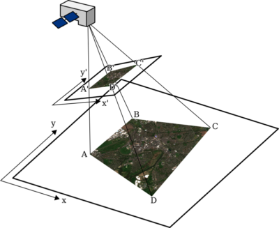
Due to the earth’s curvature, the perspective of satellite images is distorted. This distortion needs to be mathematically corrected and overlaid with location data, using a process called rubbersheeting, for precise geolocation.
A typical radar manifest contains half a billion data points, presented as a grid.

“You can’t just take radar data and make an image from it,” said Murray. “There’s a lot of processing and math involved, and that’s where the GPUs come in.”
Murray wrote the code for cuSAR using NVIDIA RAPIDS and Python Numba CUDA, which matches the radar and location data seamlessly.
Traditional Java or Python code would usually take around 40 minutes to provide an output. Backed by an NVIDIA GPU, it takes only four seconds.
Once the data has been processed, the platform outputs an image with accurate geographic information that corresponds to Ordnance Survey grid coordinates.
Within 15 minutes of receiving the satellite data, it can be placed in the hands of the emergency relief teams, giving them the knowledge to effectively react to a rapidly evolving situation on the ground.
Flood Protection for the Future
In the last decade, the U.K. has seen several of its wettest months on record. Notably, 2020 was the first year on record that fell in the top 10 for all three key weather rankings — warmest, wettest and sunniest. The Met Office predicts that severe flash flooding could be nearly five times more likely in 50 years time.
Technology like cuSAR enables researchers and emergency responders to monitor and react to disasters in a timely manner, protecting homes and businesses that are most vulnerable to worsening weather conditions.
Learn more about technology breakthroughs at GTC, running March 21-24.
Feature image courtesy of Copernicus Sentinel data, processed by ESA CC BY-SA 3.0.
The post Rain or Shine: Radar Vision Sees Through Clouds to Support Emergency Flood Relief appeared first on The Official NVIDIA Blog.
